
Thank you for supporting this site ❤️
Make a donation
Make a donation
Mojo topographic map
Click on the map to display elevation.
Thank you for supporting this site ❤️
Make a donation
Make a donation
Mojo
Mojo (Oromo: Moojoo, Amharic: ሞጆ) is a town in central Ethiopia, named after the nearby Modjo River. Located in the East Shewa Zone of the Oromia Region, it has a latitude and longitude of 8°39′N 39°5′E / 8.650°N 39.083°E / 8.650; 39.083 with an elevation between 1788 and 1825 meters above sea level. It is the administrative center of Lome district.
Thank you for supporting this site ❤️
Make a donation
Make a donation
About this map
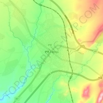
Name: Mojo topographic map, elevation, terrain.
Location: Mojo, East Shewa, Oromia Region, Ethiopia (8.54699 39.08500 8.62699 39.16500)
Average elevation: 1,800 m
Minimum elevation: 1,681 m
Maximum elevation: 1,986 m
Thank you for supporting this site ❤️
Make a donation
Make a donation