
Port-à-Piment topographic map
Interactive map
Click on the map to display elevation.
About this map
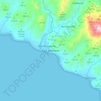
Name: Port-à-Piment topographic map, elevation, terrain.
Average elevation: 95 m
Minimum elevation: 0 m
Maximum elevation: 804 m
Other topographic maps
Click on a map to view its topography, its elevation and its terrain.
Désert
Haïti > Département du Sud > Commune Port-à-Piment
Désert, 1re Paricot, Commune Port-à-Piment, Arrondissement des Côteaux, Département du Sud, Haïti
Average elevation: 437 m
Guillaume
Haïti > Département du Sud > Commune Port-à-Piment
Guillaume, Commune Port-à-Piment, Arrondissement des Côteaux, Département du Sud, Haïti
Average elevation: 314 m