
Thank you for supporting this site ❤️
Make a donation
Make a donation
Wilson topographic map
Click on the map to display elevation.
Thank you for supporting this site ❤️
Make a donation
Make a donation
About this map
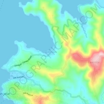
Name: Wilson topographic map, elevation, terrain.
Location: Wilson, Dinagat Islands, Caraga, 8427, Philippines (10.00441 125.56858 10.04441 125.60858)
Average elevation: 57 m
Minimum elevation: -1 m
Maximum elevation: 237 m
Thank you for supporting this site ❤️
Make a donation
Make a donation
Other topographic maps
Click on a map to view its topography, its elevation and its terrain.