
Thank you for supporting this site ❤️
Make a donation
Make a donation
Broadmayne topographic map
Click on the map to display elevation.
Thank you for supporting this site ❤️
Make a donation
Make a donation
About this map
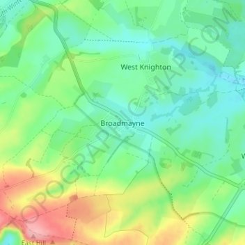
Name: Broadmayne topographic map, elevation, terrain.
Location: Broadmayne, Dorset, England, DT2 8DG, Vereinigtes Königreich (50.65811 -2.40610 50.69811 -2.36610)
Average elevation: 77 m
Minimum elevation: 39 m
Maximum elevation: 158 m
Thank you for supporting this site ❤️
Make a donation
Make a donation
Other topographic maps
Click on a map to view its topography, its elevation and its terrain.
Thank you for supporting this site ❤️
Make a donation
Make a donation
Thank you for supporting this site ❤️
Make a donation
Make a donation