
Thank you for supporting this site ❤️
Make a donation
Make a donation
Leithfield topographic map
Click on the map to display elevation.
Thank you for supporting this site ❤️
Make a donation
Make a donation
About this map
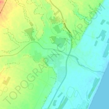
Name: Leithfield topographic map, elevation, terrain.
Location: Leithfield, Hurunui District, 7481, New Zealand (-43.21071 172.71989 -43.17071 172.75989)
Average elevation: 19 m
Minimum elevation: 0 m
Maximum elevation: 51 m
Thank you for supporting this site ❤️
Make a donation
Make a donation
Other topographic maps
Click on a map to view its topography, its elevation and its terrain.