
Thank you for supporting this site ❤️
Make a donation
Make a donation
Stengerts topographic map
Click on the map to display elevation.
Thank you for supporting this site ❤️
Make a donation
Make a donation
About this map
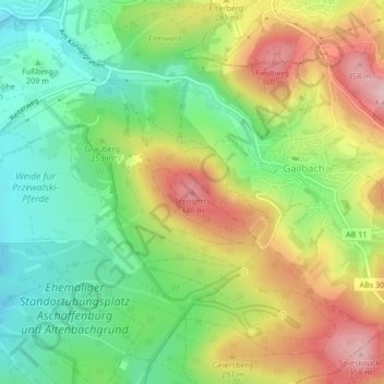
Name: Stengerts topographic map, elevation, terrain.
Location: Stengerts, Aschaffenburg, Bayern, 63808, Deutschland (49.94467 9.19585 49.94477 9.19595)
Average elevation: 248 m
Minimum elevation: 163 m
Maximum elevation: 361 m
Thank you for supporting this site ❤️
Make a donation
Make a donation
Other topographic maps
Click on a map to view its topography, its elevation and its terrain.