
El Paso topographic map
Click on the map to display elevation.
El Paso
El Paso is characterized by a diverse and striking topography shaped by its desert environment and mountainous landscapes. The city is situated at an average elevation of approximately 3,700 feet above sea level, surrounded by the rugged Franklin Mountains to the west, where peaks exceed 7,000 feet. This range is part of the southern Rocky Mountains and features steep slopes, rocky outcrops, and deep canyons, providing a dramatic backdrop to the urban landscape. The area is predominantly within the Chihuahuan Desert, contributing to its arid climate and sparse vegetation, which includes cacti and other hardy plants. Additionally, the Rio Grande flows along the city's southern boundary, creating a fertile valley that contrasts sharply with the surrounding desert terrain. This combination of mountains, desert, and river valleys not only defines the physical landscape of El Paso but also influences local climate patterns and biodiversity, making it a unique geographic region within Texas.
About this map
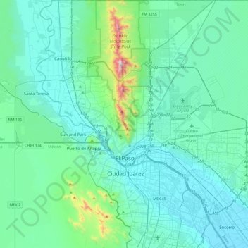
Name: El Paso topographic map, elevation, terrain.
Location: El Paso, El Paso County, Texas, United States (31.62222 -106.63578 32.00148 -106.19915)
Average elevation: 1,237 m
Minimum elevation: 1,111 m
Maximum elevation: 2,160 m
Other topographic maps
Click on a map to view its topography, its elevation and its terrain.
Rio Vista Addition Colonia
United States > Texas > El Paso County > Socorro
Average elevation: 1,116 m
Anthony
United States > Texas > El Paso County
Anthony has a desert climate, with a high degree of diurnal temperature variation due to the relatively high elevation and aridity.
Average elevation: 1,173 m
Mc Arthur Park
United States > Texas > El Paso County > El Paso > Cielo Vista
Average elevation: 1,199 m
Colonia del Rio Number 1
United States > Texas > El Paso County > San Elizario
Average elevation: 1,108 m