
Thank you for supporting this site ❤️
Make a donation
Make a donation
Kinton topographic map
Click on the map to display elevation.
Thank you for supporting this site ❤️
Make a donation
Make a donation
About this map
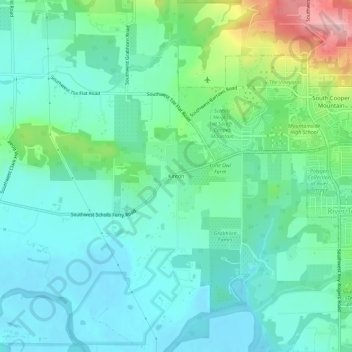
Name: Kinton topographic map, elevation, terrain.
Location: Kinton, Washington County, Oregon, 97007, United States (45.40309 -122.89811 45.44309 -122.85811)
Average elevation: 78 m
Minimum elevation: 34 m
Maximum elevation: 221 m
Thank you for supporting this site ❤️
Make a donation
Make a donation
Other topographic maps
Click on a map to view its topography, its elevation and its terrain.
Thank you for supporting this site ❤️
Make a donation
Make a donation
Thank you for supporting this site ❤️
Make a donation
Make a donation