
Athens topographic map
Interactive map
Click on the map to display elevation.
About this map
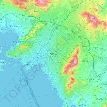
Name: Athens topographic map, elevation, terrain.
Average elevation: 168 m
Minimum elevation: -3 m
Maximum elevation: 1,091 m
The southern section of the Athens metropolitan area (i.e., Elliniko, Athens Riviera) lies in the transitional zone between Mediterranean (Csa) and hot semi-arid climate (BSh), with its port-city of Piraeus being the most extreme example, receiving just 331.9 millimetres (13.07 in) per year. The areas to the south generally see less extreme temperature variations as their climate is moderated by the Saronic gulf. The northern part of the city (i.e., Kifissia), owing to its higher elevation, features moderately lower temperatures and slightly increased precipitation year-round. The generally dry climate of the Athens basin compared to the precipitation amounts seen in a typical Mediterranean climate is due to the rain shadow effect caused by the Pindus mountain range and the Dirfys and Parnitha mountains, substantially drying the westerly and northerly winds respectively.