
Thank you for supporting this site ❤️
Make a donation
Make a donation
Fléty topographic map
Click on the map to display elevation.
Thank you for supporting this site ❤️
Make a donation
Make a donation
About this map
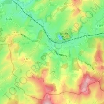
Name: Fléty topographic map, elevation, terrain.
Average elevation: 301 m
Minimum elevation: 206 m
Maximum elevation: 426 m
Thank you for supporting this site ❤️
Make a donation
Make a donation
Other topographic maps
Click on a map to view its topography, its elevation and its terrain.
Belleveaux
Frankrijk > Bourgondië-Franche-Comté > Nièvre > Saint-Honoré-les-Bains
Average elevation: 253 m
Thank you for supporting this site ❤️
Make a donation
Make a donation
Thank you for supporting this site ❤️
Make a donation
Make a donation
Courty
Frankrijk > Bourgondië-Franche-Comté > Nièvre > Château-Chinon (Campagne) > Courty
Average elevation: 490 m