
Thank you for supporting this site ❤️
Make a donation
Make a donation
Grendi topographic map
Click on the map to display elevation.
Thank you for supporting this site ❤️
Make a donation
Make a donation
About this map
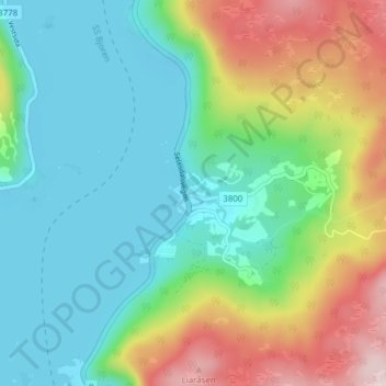
Name: Grendi topographic map, elevation, terrain.
Location: Grendi, Bygland, Agder, 4742, Norway (58.68702 7.80599 58.72702 7.84599)
Average elevation: 334 m
Minimum elevation: 200 m
Maximum elevation: 640 m
Thank you for supporting this site ❤️
Make a donation
Make a donation
Other topographic maps
Click on a map to view its topography, its elevation and its terrain.
Thank you for supporting this site ❤️
Make a donation
Make a donation