
Thank you for supporting this site ❤️
Make a donation
Make a donation
Gholson topographic map
Click on the map to display elevation.
Thank you for supporting this site ❤️
Make a donation
Make a donation
About this map
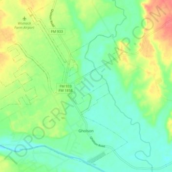
Name: Gholson topographic map, elevation, terrain.
Location: Gholson, McLennan County, Texas, United States (31.68681 -97.27967 31.75223 -97.19619)
Average elevation: 141 m
Minimum elevation: 119 m
Maximum elevation: 180 m
Thank you for supporting this site ❤️
Make a donation
Make a donation
Other topographic maps
Click on a map to view its topography, its elevation and its terrain.
Thank you for supporting this site ❤️
Make a donation
Make a donation
Northcrest
United States > Texas > McLennan County > Lacy-Lakeview > Northcrest
Average elevation: 149 m
Thank you for supporting this site ❤️
Make a donation
Make a donation