
Thank you for supporting this site ❤️
Make a donation
Make a donation
Mountain Grove topographic map
Click on the map to display elevation.
Thank you for supporting this site ❤️
Make a donation
Make a donation
About this map
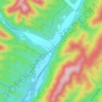
Name: Mountain Grove topographic map, elevation, terrain.
Location: Mountain Grove, Bath County, Virginia, United States (38.07874 -79.90672 38.11874 -79.86672)
Average elevation: 665 m
Minimum elevation: 521 m
Maximum elevation: 887 m
Thank you for supporting this site ❤️
Make a donation
Make a donation
Other topographic maps
Click on a map to view its topography, its elevation and its terrain.