
Thank you for supporting this site ❤️
Make a donation
Make a donation
Fort Braden topographic map
Click on the map to display elevation.
Thank you for supporting this site ❤️
Make a donation
Make a donation
About this map
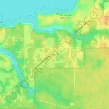
Name: Fort Braden topographic map, elevation, terrain.
Location: Fort Braden, Leon County, Florida, United States (30.40298 -84.55769 30.44298 -84.51769)
Average elevation: 36 m
Minimum elevation: 19 m
Maximum elevation: 51 m
Thank you for supporting this site ❤️
Make a donation
Make a donation
Other topographic maps
Click on a map to view its topography, its elevation and its terrain.