
Thank you for supporting this site ❤️
Make a donation
Make a donation
Bad Kohlgrub topographic map
Click on the map to display elevation.
Thank you for supporting this site ❤️
Make a donation
Make a donation
About this map
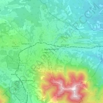
Name: Bad Kohlgrub topographic map, elevation, terrain.
Average elevation: 889 m
Minimum elevation: 670 m
Maximum elevation: 1,525 m
Thank you for supporting this site ❤️
Make a donation
Make a donation
Other topographic maps
Click on a map to view its topography, its elevation and its terrain.
Schaffelberg
Duitsland > Beieren > Landkreis Garmisch-Partenkirchen > Oberammergau
Average elevation: 1,095 m
Höllentalferner
Duitsland > Beieren > Landkreis Garmisch-Partenkirchen > Grainau
Average elevation: 2,226 m