
Make a donation
Palm Harbor topographic map
Click on the map to display elevation.
Make a donation
About this map
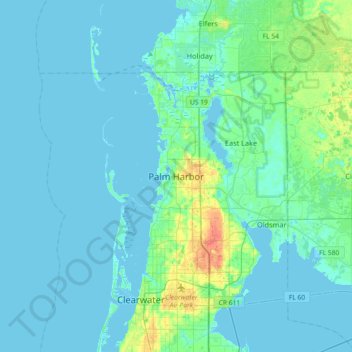
Name: Palm Harbor topographic map, elevation, terrain.
Location: Palm Harbor, Pinellas County, Florida, 34683, United States (28.03807 -82.80371 28.11807 -82.72371)
Average elevation: 9 m
Minimum elevation: -2 m
Maximum elevation: 32 m
Make a donation
Other topographic maps
Click on a map to view its topography, its elevation and its terrain.
Largo
United States > Florida > Pinellas County
In 2010, Largo's total area was 18.6 square miles (48.1 km2), of which 17.6 square miles (45.6 km2) was land and 0.97 square miles (2.5 km2), or 5.22%, was water. As of 2004, there were 651 acres (2.6 km2) of park lands. The city's lowest elevation is sea level. At its highest, the city's elevation is about 69…
Average elevation: 9 m
Oldsmar
United States > Florida > Pinellas County
In 1921, a hurricane hit Tampa Bay. Because Oldsmar sits on a plateau with an elevation never rising over 20 feet (6.1 m) above sea level, it was devastated by the storm. Large trees were uprooted and floodwater reached levels 14 feet (4.3 m) above normal. Some of the homes that survived the storm were moved,…
Average elevation: 6 m
Make a donation