
Make a donation
Onondaga County topographic map
Click on the map to display elevation.
Make a donation
Onondaga County
According to the U.S. Census Bureau, the county has an area of 806 square miles (2,090 km2), of which 778 square miles (2,020 km2) is land and 27 square miles (70 km2) (3.4%) is water. The geographic dimensions of the county are illustrated as approximately 35 miles (56 km) in length and 30 miles (48 km) in width, and comprising 25 miles (40 km) of the New York State Barge Canal System, in combination with a number of lakes, streams and rivers. Onondaga County is in the central portion of New York State, west of Albany and Utica, east of Rochester and northeast of Ithaca. Onondaga Lake is bordered by many of the larger communities in the county. The highest point in Onondaga County is at 2057 feet, along Morgan Hill located just east of Morgan Hill State Forest on private property. The second highest point in Onondaga County is at 2019 feet elevation and on the summit of Fellows Hill which is located in Morgan Hill State Forest near Fabius and Apulia south of state route 80.
Make a donation
About this map
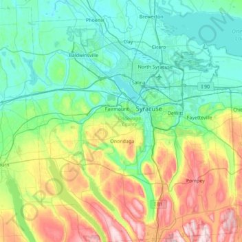
Name: Onondaga County topographic map, elevation, terrain.
Location: Onondaga County, New York, United States (42.77129 -76.49957 43.27159 -75.89582)
Average elevation: 233 m
Minimum elevation: 104 m
Maximum elevation: 620 m
Make a donation
Other topographic maps
Click on a map to view its topography, its elevation and its terrain.
Central Park
United States > New York > New York County > New York
In June 1856, Fernando Wood appointed a "consulting board" of seven people, headed by author Washington Irving, to inspire public confidence in the proposed development. Wood hired military engineer Egbert Ludovicus Viele as the park's chief engineer, tasking him with a topographical survey of the site. The…
Average elevation: 26 m
Brooklyn Bridge Park
United States > New York > Kings County > New York
Brooklyn Bridge Park spans 85 acres (34 ha) of the East River waterfront in the Brooklyn Heights and Dumbo neighborhoods of Brooklyn. The park is divided into eleven sections: Piers 1 through 6; Fulton Ferry Landing; Brooklyn Bridge Plaza; Empire Fulton Ferry; Main Street; and John Street. Each of these…
Average elevation: 9 m
Central Park
United States > New York > New York County > New York
In June 1856, Fernando Wood appointed a "consulting board" of seven people, headed by author Washington Irving, to inspire public confidence in the proposed development. Wood hired military engineer Egbert Ludovicus Viele as the park's chief engineer, tasking him with a topographical survey of the site. The…
Average elevation: 26 m
Make a donation
Make a donation
East Poestenkill
United States > New York > Rensselaer County > Town of Poestenkill
Average elevation: 376 m
Make a donation
Chenango Lake
United States > New York > Chenango County > Town of New Berlin
Average elevation: 513 m
Make a donation
Tusten Mountain Lake
United States > New York > Sullivan County > Town of Tusten
Average elevation: 346 m
North Germantown
United States > New York > Columbia County > Town of Germantown
Average elevation: 34 m
Make a donation
Hoopers Valley Island
United States > New York > Tioga County > Hoopers Valley
Average elevation: 267 m
Tug Hill
United States > New York > Oswego County
The core Tug Hill region encompasses 150,000 acres (610 km2) of unbroken, generally second-growth, northern hardwood forest, and is drained by a vast network of streams. Important rivers and streams whose headwaters are located within the Tug Hill region include the Mohawk River, Deer River, Salmon River, Mad…
Average elevation: 109 m
Make a donation
Barberville
United States > New York > Rensselaer County > Town of Poestenkill
Average elevation: 269 m
Mount Marcy
United States > New York > Essex County > Town of Keene
Mount Marcy is the highest point in the Adirondack Mountains and the U.S. state of New York, with an elevation of 5,343.1 feet (1,628.6 m). It is located in the town of Keene in Essex County. The mountain is in the heart of the High Peaks Wilderness Area in Adirondack Park. Like the surrounding Adirondack…
Average elevation: 1,289 m
Make a donation
Make a donation
Make a donation
Big Bad Luck Pond
United States > New York > Hamilton County > Town of Indian Lake
Average elevation: 539 m
Make a donation
Catskill mountains view
United States > New York > Greene County > Town of Hunter
Average elevation: 740 m
Make a donation
Sunset Ridge
United States > New York > Westchester County > Town/Village of Harrison
Average elevation: 27 m
Make a donation
Make a donation
Ellicottville
United States > New York > Cattaraugus County > Village of Ellicottville
Average elevation: 573 m
Make a donation
Make a donation
Barnum Corners
United States > New York > Putnam County > Town of Patterson > Putnam Lake
Average elevation: 174 m
Make a donation
Heath Ridge
United States > New York > Westchester County > Village of Scarsdale
Average elevation: 66 m
Make a donation
Make a donation
Make a donation
Lake Tonetta
United States > New York > Putnam County > Brewster > Brewster Hill
Average elevation: 155 m
Make a donation
Trumbull Corners
United States > New York > Tompkins County > Town of Newfield
Average elevation: 443 m
Make a donation
Make a donation
Whitehall Corners
United States > New York > Westchester County > Town of Somers
Average elevation: 97 m
Benjamin's Memorial Beach
United States > New York > Suffolk County > Bay Shore
Average elevation: 2 m
Make a donation
Make a donation
Upper Lansingburg Reservoir Dam
United States > New York > Rensselaer County > City of Troy
Average elevation: 92 m
Hawthorne
United States > New York > Westchester County > Town of Mount Pleasant
Average elevation: 119 m
Make a donation