
Thank you for supporting this site ❤️
Make a donation
Make a donation
Marble topographic map
Click on the map to display elevation.
Thank you for supporting this site ❤️
Make a donation
Make a donation
About this map
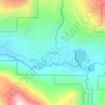
Name: Marble topographic map, elevation, terrain.
Location: Marble, Gunnison County, Colorado, United States (39.06769 -107.19962 39.07676 -107.18179)
Average elevation: 2,611 m
Minimum elevation: 2,391 m
Maximum elevation: 3,121 m
Thank you for supporting this site ❤️
Make a donation
Make a donation
Other topographic maps
Click on a map to view its topography, its elevation and its terrain.
Gunnison
United States > Colorado > Gunnison County
Also in 1880, the cattle industry in Gunnison was established. Realizing the poor conditions for farming (with only about eleven inches of rainfall annually and the short growing season due to the high elevation and alpine environment) the local farmers turned to ranching and began breeding cattle. To do this…
Average elevation: 2,369 m
Thank you for supporting this site ❤️
Make a donation
Make a donation
Thank you for supporting this site ❤️
Make a donation
Make a donation