
Thank you for supporting this site ❤️
Make a donation
Make a donation
Vollmarshausen topographic map
Click on the map to display elevation.
Thank you for supporting this site ❤️
Make a donation
Make a donation
About this map
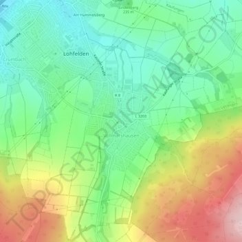
Name: Vollmarshausen topographic map, elevation, terrain.
Location: Vollmarshausen, Lohfelden, Landkreis Kassel, Hessen, Deutschland (51.24466 9.54522 51.28017 9.59813)
Average elevation: 251 m
Minimum elevation: 165 m
Maximum elevation: 395 m
Thank you for supporting this site ❤️
Make a donation
Make a donation
Other topographic maps
Click on a map to view its topography, its elevation and its terrain.
Am Hammelsberg
Deutschland > Hessen > Landkreis Kassel > Lohfelden > Ochshausen
Average elevation: 198 m