
Thank you for supporting this site ❤️
Make a donation
Make a donation
Abercarn topographic map
Click on the map to display elevation.
Thank you for supporting this site ❤️
Make a donation
Make a donation
About this map
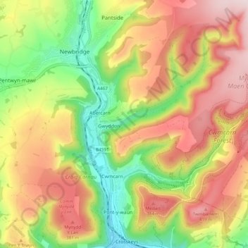
Name: Abercarn topographic map, elevation, terrain.
Location: Abercarn, Caerphilly County Borough, Wales, United Kingdom (51.62997 -3.16817 51.66595 -3.07270)
Average elevation: 263 m
Minimum elevation: 60 m
Maximum elevation: 463 m
Thank you for supporting this site ❤️
Make a donation
Make a donation
Other topographic maps
Click on a map to view its topography, its elevation and its terrain.
Thank you for supporting this site ❤️
Make a donation
Make a donation
Thank you for supporting this site ❤️
Make a donation
Make a donation
Caerphilly Mountain
United Kingdom > Wales > Caerphilly County Borough > Caerphilly
Average elevation: 171 m
Thank you for supporting this site ❤️
Make a donation
Make a donation
Thank you for supporting this site ❤️
Make a donation
Make a donation
Rudry Common
United Kingdom > Wales > Caerphilly County Borough > Trethomas > Rudry
Average elevation: 131 m
Thank you for supporting this site ❤️
Make a donation
Make a donation
Bedwellty
United Kingdom > Wales > Caerphilly County Borough > Bargoed > Aberbargoed
Average elevation: 253 m
Thank you for supporting this site ❤️
Make a donation
Make a donation
Thank you for supporting this site ❤️
Make a donation
Make a donation