
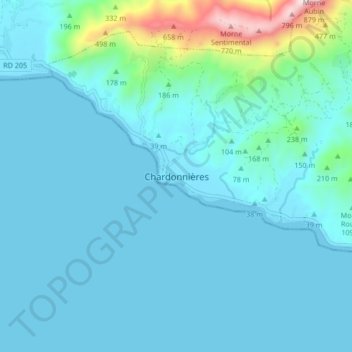
Chardonnières topographic map
Interactive map
Click on the map to display elevation.
About this map
Name: Chardonnières topographic map, elevation, terrain.
Average elevation: 93 m
Minimum elevation: 0 m
Maximum elevation: 817 m
Other topographic maps
Click on a map to view its topography, its elevation and its terrain.
Rivière de Port-à-Piment
Haïti > Département du Sud > Commune Chardonnieres
Rivière de Port-à-Piment, Commune Chardonnieres, Arrondissement des Chardonnières, Département du Sud, Haïti
Average elevation: 122 m