
Thank you for supporting this site ❤️
Make a donation
Make a donation
Litermont topographic map
Click on the map to display elevation.
Thank you for supporting this site ❤️
Make a donation
Make a donation
Litermont
Der im Saarland gelegene Litermont ist ein Höhenzug von bis zu 414,2 m ü. NHN und erstreckt sich größtenteils in das Nalbacher Tal, mit kleineren Ausläufern bis nach Düppenweiler.
Thank you for supporting this site ❤️
Make a donation
Make a donation
About this map
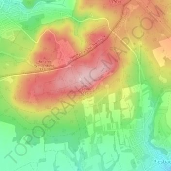
Name: Litermont topographic map, elevation, terrain.
Average elevation: 306 m
Minimum elevation: 209 m
Maximum elevation: 406 m
Thank you for supporting this site ❤️
Make a donation
Make a donation
Other topographic maps
Click on a map to view its topography, its elevation and its terrain.
Körprich
Deutschland > Saarland > Landkreis Saarlouis > Nalbach
Im Jahre 2006 versuchte man im Zuge des geplanten Kohleabbaues die gefährdete Hangrutschlage am Hoxberg durch einen 400 m langen Entwässerungskanal und weitere Maßnahmen mit einem Gesamtaufwand in Höhe von 5 Mio. Euro zu sichern.
Average elevation: 257 m