
Thank you for supporting this site ❤️
Make a donation
Make a donation
Fort Langley topographic map
Click on the map to display elevation.
Thank you for supporting this site ❤️
Make a donation
Make a donation
About this map
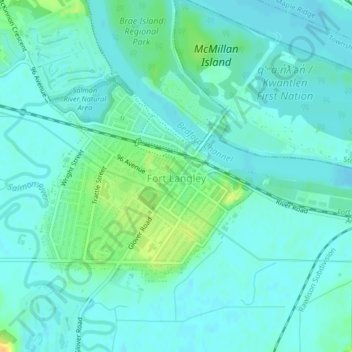
Name: Fort Langley topographic map, elevation, terrain.
Average elevation: 7 m
Minimum elevation: 0 m
Maximum elevation: 29 m
Thank you for supporting this site ❤️
Make a donation
Make a donation
Other topographic maps
Click on a map to view its topography, its elevation and its terrain.
South Aldergrove Park
Canada > British Columbia > Metro Vancouver Regional District > Township of Langley
Average elevation: 104 m