
Make a donation
Nimpo Lake topographic map
Click on the map to display elevation.
Make a donation
About this map
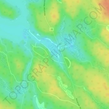
Name: Nimpo Lake topographic map, elevation, terrain.
Average elevation: 1,131 m
Minimum elevation: 1,115 m
Maximum elevation: 1,151 m
Make a donation
Other topographic maps
Click on a map to view its topography, its elevation and its terrain.
Anahim Lake
Canada > British Columbia > Cariboo Regional District > Area J (West Chilcotin)
Average elevation: 1,101 m
Mount Juno
Canada > British Columbia > Cariboo Regional District > Area J (West Chilcotin)
Average elevation: 2,219 m
Nimpo Lake
Canada > British Columbia > Cariboo Regional District > Area J (West Chilcotin)
Nimpo Lake is the jumping off point to the wilderness, much of it inaccessible to people except by floatplane or on foot. You can go flightseeing over Hunlen Falls, the third longest freefalling waterfall in Canada, or fly over the multicolored Rainbow Mountains or Monarch Mountain and see the pristine…
Average elevation: 1,150 m
Heckman Pass
Canada > British Columbia > Cariboo Regional District > Area J (West Chilcotin)
Average elevation: 1,519 m
Make a donation
Tŝilhqox Biny (Chilko Lake)
Canada > British Columbia > Cariboo Regional District > Area J (West Chilcotin)
Tŝilhqox Biny (Pronounced: Tsyle-koh Bee), known as Chilko Lake, is a 180 km2 lake in west-central British Columbia, at the head of the Chilko River on the Chilcotin Plateau. The lake is about 65 km long, with a southwest arm 10 km long. It is one of the largest lakes by volume in the province because of its…
Average elevation: 1,739 m
Itcha Range
Canada > British Columbia > Cariboo Regional District > Area J (West Chilcotin)
Average elevation: 1,747 m
Ilgachuz Range
Canada > British Columbia > Cariboo Regional District > Area J (West Chilcotin)
The Ilgachuz Range is a name given to an extinct shield volcano in British Columbia, Canada. It is not a mountain range in the normal sense, because it was formed as a single volcano that has been eroded for the past five million years. It lies on the Chilcotin Plateau, located some 350 kilometres (220 mi)…
Average elevation: 2,018 m
Rainbow Range
Canada > British Columbia > Cariboo Regional District > Area J (West Chilcotin)
Average elevation: 1,741 m
Make a donation
Tatla Lake
Canada > British Columbia > Cariboo Regional District > Area J (West Chilcotin)
Average elevation: 1,080 m
Anahim Peak
Canada > British Columbia > Cariboo Regional District > Area J (West Chilcotin)
Average elevation: 1,416 m
Puntzi Mountain
Canada > British Columbia > Cariboo Regional District > Area J (West Chilcotin)
Average elevation: 1,293 m
The Joker
Canada > British Columbia > Cariboo Regional District > Area J (West Chilcotin)
Average elevation: 2,157 m
Make a donation
Tŝilhqox Biny (Chilko Lake)
Canada > British Columbia > Cariboo Regional District > Area J (West Chilcotin)
Tŝilhqox Biny (Pronounced: Tsyle-koh Bee), known as Chilko Lake, is a 180 km2 lake in west-central British Columbia, at the head of the Chilko River on the Chilcotin Plateau. The lake is about 65 km long, with a southwest arm 10 km long. It is one of the largest lakes by volume in the province because of its…
Average elevation: 1,739 m