
Shigatse topographic map
Interactive map
Click on the map to display elevation.
Shigatse
Shigatse Peace Airport began operations on 30 October 2010 after an Airbus A319 landed safely, making it Tibet's fifth commercial airport. It is located 43 kilometres from Samzhubzê District at Jangdam Township at an elevation of 3,782 metres. The airport will be capable of supporting 230,000 passengers annually by 2020.
About this map
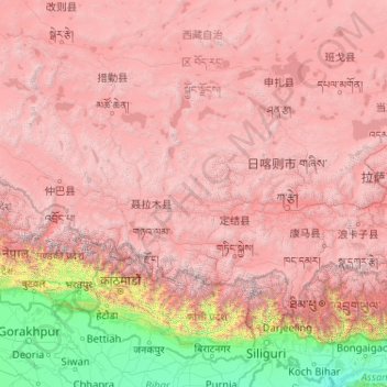
Name: Shigatse topographic map, elevation, terrain.
Location: Shigatse, Tibet, China (27.30540 82.13764 31.80997 90.34500)
Average elevation: 3,810 m
Minimum elevation: 25 m
Maximum elevation: 8,013 m
Other topographic maps
Click on a map to view its topography, its elevation and its terrain.
Mount Everest
China > Tibet > Tingri County
Mount Everest (Nepali: सगरमाथा, romanized: Sagarmāthā; Tibetan: Chomolungma ཇོ་མོ་གླང་མ; Chinese: 珠穆朗玛峰; pinyin: Zhūmùlǎngmǎ Fēng) is Earth's highest mountain above sea level, located in the Mahalangur Himal sub-range of the Himalayas. The China–Nepal…
Average elevation: 7,850 m