
Thank you for supporting this site ❤️
Make a donation
Make a donation
Springfield topographic map
Click on the map to display elevation.
Thank you for supporting this site ❤️
Make a donation
Make a donation
About this map
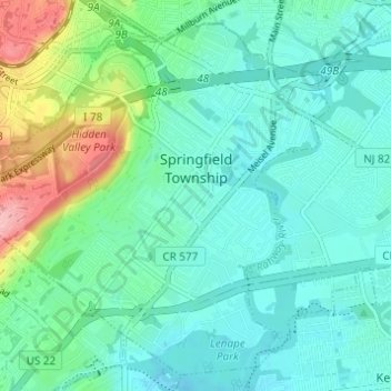
Name: Springfield topographic map, elevation, terrain.
Location: Springfield, Union County, New Jersey, 07081, United States (40.67743 -74.36039 40.72010 -74.29915)
Average elevation: 63 m
Minimum elevation: 18 m
Maximum elevation: 167 m
Thank you for supporting this site ❤️
Make a donation
Make a donation
Other topographic maps
Click on a map to view its topography, its elevation and its terrain.
Thank you for supporting this site ❤️
Make a donation
Make a donation
Staten Island Junction
United States > New Jersey > Union County > Cranford > Staten Island Junction
Average elevation: 24 m
Thank you for supporting this site ❤️
Make a donation
Make a donation