
Parc national de la Gaspésie topographic map
Interactive map
Click on the map to display elevation.
About this map
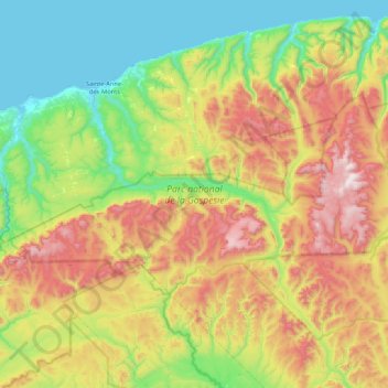
Name: Parc national de la Gaspésie topographic map, elevation, terrain.
Average elevation: 440 m
Minimum elevation: -3 m
Maximum elevation: 1,271 m
Other topographic maps
Click on a map to view its topography, its elevation and its terrain.
Gaspésie
Canada > Québec > La Haute-Gaspésie > Mont-Albert
Gaspésie, Mont-Albert, La Haute-Gaspésie, Gaspésie–Îles-de-la-Madeleine, Québec, Canada
Average elevation: 459 m
Rivière Madeleine
Canada > Québec > La Haute-Gaspésie > Mont-Albert
Rivière Madeleine, Mont-Albert, La Haute-Gaspésie, Gaspésie–Îles-de-la-Madeleine, Québec, Canada
Average elevation: 753 m