
Thank you for supporting this site ❤️
Make a donation
Make a donation
Dummerston topographic map
Click on the map to display elevation.
Thank you for supporting this site ❤️
Make a donation
Make a donation
About this map
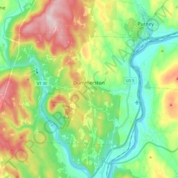
Name: Dummerston topographic map, elevation, terrain.
Location: Dummerston, Windham County, Vermont, 05357, United States (42.89612 -72.67736 42.96920 -72.51975)
Average elevation: 216 m
Minimum elevation: 62 m
Maximum elevation: 503 m
Thank you for supporting this site ❤️
Make a donation
Make a donation
Other topographic maps
Click on a map to view its topography, its elevation and its terrain.