
Thank you for supporting this site ❤️
Make a donation
Make a donation
Schwarz topographic map
Click on the map to display elevation.
Thank you for supporting this site ❤️
Make a donation
Make a donation
About this map
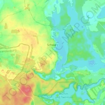
Name: Schwarz topographic map, elevation, terrain.
Average elevation: 76 m
Minimum elevation: 57 m
Maximum elevation: 116 m
Thank you for supporting this site ❤️
Make a donation
Make a donation
Other topographic maps
Click on a map to view its topography, its elevation and its terrain.
Strehlow
Deutschland > Mecklenburg-Vorpommern > Mecklenburgische Seenplatte > Hohenbrünzow
Average elevation: 41 m
Törpin
Deutschland > Mecklenburg-Vorpommern > Mecklenburgische Seenplatte > Sarow
Average elevation: 54 m
Loickenzin
Deutschland > Mecklenburg-Vorpommern > Mecklenburgische Seenplatte > Altentreptow > Loickenzin
Average elevation: 43 m
Thank you for supporting this site ❤️
Make a donation
Make a donation
Lindow
Deutschland > Mecklenburg-Vorpommern > Mecklenburgische Seenplatte > Lindow
Average elevation: 73 m
Bresewitz
Deutschland > Mecklenburg-Vorpommern > Mecklenburgische Seenplatte > Friedland
Average elevation: 23 m