
Bláhnúkur topographic map
Interactive map
Click on the map to display elevation.
About this map
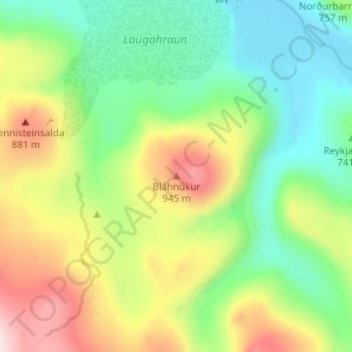
Name: Bláhnúkur topographic map, elevation, terrain.
Location: Bláhnúkur, Rangárþing ytra, Southern Region, Iceland (63.97672 -19.06922 63.97682 -19.06912)
Average elevation: 730 m
Minimum elevation: 592 m
Maximum elevation: 960 m
Other topographic maps
Click on a map to view its topography, its elevation and its terrain.
Frostastaðavatn
Frostastaðavatn, Rangárþing ytra, Southern Region, Iceland
Average elevation: 602 m
Hnausapollur
Hnausapollur, Rangárþing ytra, Southern Region, Iceland
Average elevation: 608 m