
Thank you for supporting this site ❤️
Make a donation
Make a donation
المهدية topographic map
Click on the map to display elevation.
Thank you for supporting this site ❤️
Make a donation
Make a donation
About this map
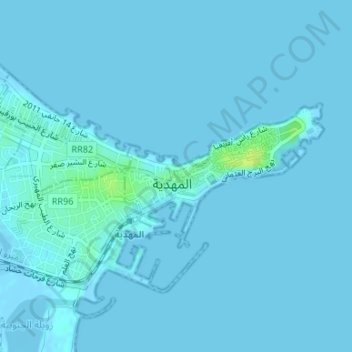
Name: المهدية topographic map, elevation, terrain.
Location: المهدية, معتمدية المهدية, Mahdia, 5129, Tunisia (35.49875 11.06371 35.50980 11.08258)
Average elevation: 1 m
Minimum elevation: -2 m
Maximum elevation: 14 m
Thank you for supporting this site ❤️
Make a donation
Make a donation