
Hamlet of Antler Lake topographic map
Interactive map
Click on the map to display elevation.
About this map
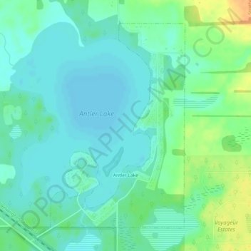
Name: Hamlet of Antler Lake topographic map, elevation, terrain.
Location: Hamlet of Antler Lake, Strathcona County, Alberta, Canada (53.48295 -112.98830 53.50501 -112.96394)
Average elevation: 745 m
Minimum elevation: 735 m
Maximum elevation: 769 m
Other topographic maps
Click on a map to view its topography, its elevation and its terrain.
Hastings Lake
Canada > Alberta > Strathcona County
Hastings Lake, Strathcona County, Alberta, Canada
Average elevation: 744 m
Hamlet of Josephburg
Canada > Alberta > Strathcona County > Hamlet of Josephburg
Hamlet of Josephburg, Strathcona County, Alberta, T8L 4B8, Canada
Average elevation: 639 m
Ardrossan
Canada > Alberta > Strathcona County
Ardrossan, Strathcona County, Alberta, T8E 2A2, Canada
Average elevation: 710 m
Cooking Lake
Canada > Alberta > Strathcona County
Cooking Lake, Strathcona County, Alberta, Canada
Average elevation: 745 m