
Thank you for supporting this site ❤️
Make a donation
Make a donation
Fletcher topographic map
Click on the map to display elevation.
Thank you for supporting this site ❤️
Make a donation
Make a donation
About this map
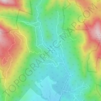
Name: Fletcher topographic map, elevation, terrain.
Location: Fletcher, Greene County, Virginia, United States (38.37291 -78.45334 38.41291 -78.41334)
Average elevation: 439 m
Minimum elevation: 235 m
Maximum elevation: 795 m
Thank you for supporting this site ❤️
Make a donation
Make a donation
Other topographic maps
Click on a map to view its topography, its elevation and its terrain.