
Thank you for supporting this site ❤️
Make a donation
Make a donation
Starlight Park topographic map
Click on the map to display elevation.
Thank you for supporting this site ❤️
Make a donation
Make a donation
About this map
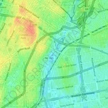
Name: Starlight Park topographic map, elevation, terrain.
Average elevation: 17 m
Minimum elevation: 0 m
Maximum elevation: 42 m
Thank you for supporting this site ❤️
Make a donation
Make a donation
Other topographic maps
Click on a map to view its topography, its elevation and its terrain.
Roberto Clemente State Park
United States > New York > Bronx County > New York
Average elevation: 32 m
Thank you for supporting this site ❤️
Make a donation
Make a donation