
Thank you for supporting this site ❤️
Make a donation
Make a donation
16909 topographic map
Click on the map to display elevation.
Thank you for supporting this site ❤️
Make a donation
Make a donation
About this map
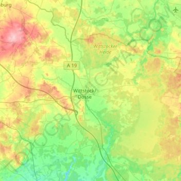
Name: 16909 topographic map, elevation, terrain.
Average elevation: 78 m
Minimum elevation: 39 m
Maximum elevation: 152 m
Thank you for supporting this site ❤️
Make a donation
Make a donation
Other topographic maps
Click on a map to view its topography, its elevation and its terrain.
Badestelle Dranser See
Deutschland > Brandenburg > Ostprignitz-Ruppin > Wittstock/Dosse
Average elevation: 78 m