
Make a donation
Mountain Springs topographic map
Click on the map to display elevation.
Make a donation
About this map
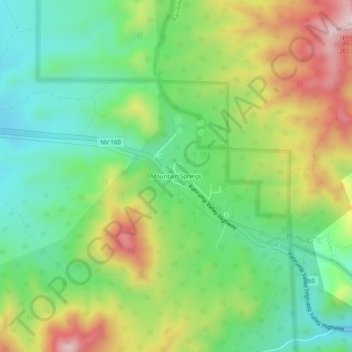
Name: Mountain Springs topographic map, elevation, terrain.
Location: Mountain Springs, Clark County, Nevada, United States (35.99853 -115.52686 36.03853 -115.48686)
Average elevation: 1,721 m
Minimum elevation: 1,537 m
Maximum elevation: 2,022 m
Make a donation
Other topographic maps
Click on a map to view its topography, its elevation and its terrain.
Lake Mead
United States > Nevada > Clark County
At maximum capacity, Lake Mead is 112 miles (180 km) long, 532 feet (162 m) at its greatest depth, has a surface elevation of 1,221.4 feet (372.3 m) above sea level and 247 square miles (640 km2) of surface area, and contains 26.12 million acre feet (3.222×10¹³ L) of water.
Average elevation: 684 m
Make a donation
Make a donation
Carey–Lake Mead Detention Basin
United States > Nevada > Clark County > North Las Vegas
Average elevation: 648 m
Make a donation