
Thank you for supporting this site ❤️
Make a donation
Make a donation
Panruti topographic map
Click on the map to display elevation.
Thank you for supporting this site ❤️
Make a donation
Make a donation
About this map
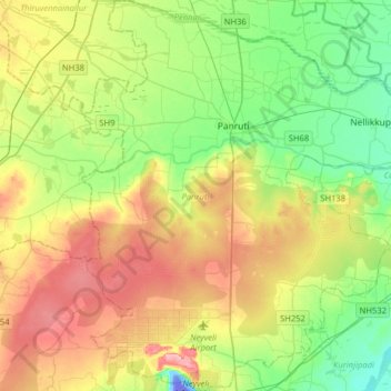
Name: Panruti topographic map, elevation, terrain.
Location: Panruti, Cuddalore District, Tamil Nadu, India (11.56055 79.42868 11.87224 79.69452)
Average elevation: 49 m
Minimum elevation: -57 m
Maximum elevation: 122 m
Thank you for supporting this site ❤️
Make a donation
Make a donation
Other topographic maps
Click on a map to view its topography, its elevation and its terrain.
Chennai
Chennai is located on the south–eastern coast of India in the north–eastern part of Tamil Nadu on a flat coastal plain known as the Eastern Coastal Plains with an average elevation of 6.7 m (22 ft) and highest point at 60 m (200 ft). Chennai's soil is mostly clay, shale and sandstone. Clay underlies most…
Average elevation: 7 m