
Thank you for supporting this site ❤️
Make a donation
Make a donation
Strandfontein topographic map
Click on the map to display elevation.
Thank you for supporting this site ❤️
Make a donation
Make a donation
About this map
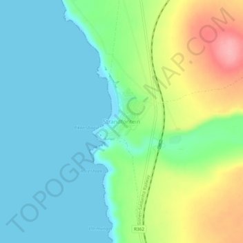
Name: Strandfontein topographic map, elevation, terrain.
Average elevation: 36 m
Minimum elevation: 0 m
Maximum elevation: 120 m
Thank you for supporting this site ❤️
Make a donation
Make a donation
Other topographic maps
Click on a map to view its topography, its elevation and its terrain.
Matzikama Ward 8
South Africa > Western Cape > West Coast District Municipality > Matzikama Local Municipality
Average elevation: 332 m