
Curaçao topographic map
Interactive map
Click on the map to display elevation.
About this map
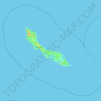
Name: Curaçao topographic map, elevation, terrain.
Location: Curaçao, Nederland (11.77700 -69.36735 12.59200 -68.44133)
Average elevation: 2 m
Minimum elevation: -1 m
Maximum elevation: 288 m
Other topographic maps
Click on a map to view its topography, its elevation and its terrain.
Driebergen-Rijsenburg
Driebergen-Rijsenburg, Utrechtse Heuvelrug, Utrecht, Nederland
Average elevation: 8 m
Twente
Nederland > Overijssel > Saasveld
Twente, Saasveld, Dinkelland, Overijssel, Nederland, 7597 KL, Nederland
Average elevation: 36 m
Voorthuizen
Voorthuizen, Barneveld, Gelderland, Nederland
Average elevation: 15 m
Alphen aan den Rijn
Alphen aan den Rijn, Zuid-Holland, Nederland
Average elevation: -2 m
Voorburg
Voorburg, Leidschendam-Voorburg, Zuid-Holland, Nederland
Average elevation: 3 m
Gorinchem
Nederland > Zuid-Holland > Gorinchem
Gorinchem, Zuid-Holland, Nederland
Average elevation: 1 m
Den Helder
Nederland > Noord-Holland > Den Helder
Den Helder, Noord-Holland, Nederland
Average elevation: 0 m
Harderwijk
Nederland > Gelderland > Harderwijk
Harderwijk, Gelderland, Nederland
Average elevation: 7 m