
Thank you for supporting this site ❤️
Make a donation
Make a donation
Koshlong Lake topographic map
Click on the map to display elevation.
Thank you for supporting this site ❤️
Make a donation
Make a donation
About this map
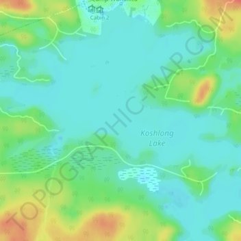
Name: Koshlong Lake topographic map, elevation, terrain.
Average elevation: 357 m
Minimum elevation: 341 m
Maximum elevation: 393 m
Thank you for supporting this site ❤️
Make a donation
Make a donation
Other topographic maps
Click on a map to view its topography, its elevation and its terrain.
Silent Lake Provincial Park
Canada > Ontario > Haliburton County > Highlands East
Average elevation: 371 m
Tory Hill Community Park
Canada > Ontario > Haliburton County > Highlands East
Average elevation: 399 m
Gooderham Lake
Canada > Ontario > Haliburton County > Highlands East > Gooderham
Average elevation: 344 m
Thank you for supporting this site ❤️
Make a donation
Make a donation
Thank you for supporting this site ❤️
Make a donation
Make a donation
Thank you for supporting this site ❤️
Make a donation
Make a donation