
Thank you for supporting this site ❤️
Make a donation
Make a donation
Melchenberg topographic map
Click on the map to display elevation.
Thank you for supporting this site ❤️
Make a donation
Make a donation
Melchenberg
Etwa 115 m nördlich der Bergkuppe steht zwischen Bäumen am Waldrand der Funkturm Groß Reken Melchenberg (132 m; ⊙51.8396805555567.0398194444444), der sowohl Mobilfunk-Sendeturm als auch Aussichtsturm ist. Er ist ein 60 m hoher Stahlfachwerkturm, der auf 30 m Höhe eine über eine Treppe mit 168 Stufen erreichbare Aussichtsplattform (162 m) hat. Eigentümer des Turmes ist die Firma Vodafone.
Thank you for supporting this site ❤️
Make a donation
Make a donation
About this map
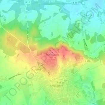
Name: Melchenberg topographic map, elevation, terrain.
Average elevation: 92 m
Minimum elevation: 62 m
Maximum elevation: 135 m
Thank you for supporting this site ❤️
Make a donation
Make a donation