
Make a donation
Alfred topographic map
Click on the map to display elevation.
Make a donation
Alfred
According to the United States Census Bureau, the town has a total area of 27.92 square miles (72.31 km2), of which 27.25 square miles (70.58 km2) is land and 0.67 square miles (1.74 km2) is water. Alfred is drained by the Middle Branch of the Mousam River, Littlefield River, Hay Brook and Trafton Brook. Yeaton Hill has an elevation of 602 feet (183 m), and Brackett Hill an elevation of 480 feet (150 m). The highest point in town is on Fort Ridge, at an elevation of 1,020 feet (310 m), at the Shapleigh line.
Make a donation
About this map
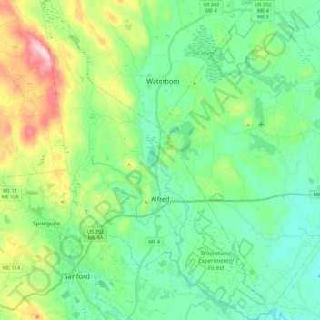
Name: Alfred topographic map, elevation, terrain.
Location: Alfred, York County, Maine, 04002, United States (43.41703 -70.79837 43.57548 -70.64232)
Average elevation: 111 m
Minimum elevation: 28 m
Maximum elevation: 336 m
Make a donation
Other topographic maps
Click on a map to view its topography, its elevation and its terrain.
Make a donation
Make a donation