
Make a donation
Mount Jarvis topographic map
Click on the map to display elevation.
Make a donation
About this map
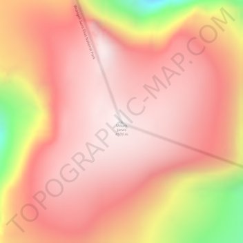
Name: Mount Jarvis topographic map, elevation, terrain.
Location: Mount Jarvis, Unorganized Borough, Alaska, United States (62.02341 -143.61979 62.02351 -143.61969)
Average elevation: 3,799 m
Minimum elevation: 3,050 m
Maximum elevation: 4,100 m
Make a donation
Other topographic maps
Click on a map to view its topography, its elevation and its terrain.
Make a donation
Make a donation
Make a donation
Make a donation
Make a donation
Make a donation
Akiak
United States > Alaska > Unorganized Borough
The airport has a gravel runway in good condition, measuring 3,196 feet (974 m) long by 75 feet (23 m) wide, at an elevation of 30 feet (9.1 m). The strip provides chartered or private air access year-round. Arctic Circle Air Service, Grant Aviation, and Hageland Aviation offer passenger flight service. Snow…
Average elevation: 5 m
Make a donation
Make a donation
Paxson
United States > Alaska > Unorganized Borough
Paxson has a continental subarctic climate (Köppen Dfc), closely bordering on an alpine climate (Köppen ET) due to its high elevation and northerly latitude, with only one month above the 50 degree isotherm.
Average elevation: 1,015 m
Make a donation
Make a donation
Make a donation
Make a donation
Make a donation
Make a donation
Make a donation
Make a donation
Chevak
United States > Alaska > Unorganized Borough
Chevak first appeared on the 1940 U.S. Census as an unincorporated native village. At the time it was located above the junction of the Keoklevik & Kashunuk Rivers at an altitude of 7 feet. 61°25′56″N 165°27′03″W / 61.43222°N 165.45083°W / 61.43222; -165.45083 (Old Chevak) In the 1940s,…
Average elevation: 8 m
Make a donation
Make a donation
Glacier Bay National Park and Preserve
United States > Alaska > Unorganized Borough > Gustavus
Average elevation: 22 m
Make a donation
Make a donation
Make a donation
Lituya Bay
United States > Alaska > Unorganized Borough
The same topography that leads to the heavy tidal currents also created the tsunami with the highest runup against a hillside in recorded history. On July 9, 1958, an earthquake caused a landslide in the Gilbert Inlet at the head of the bay, generating a massive megatsunami which had sufficient energy to run…
Average elevation: 217 m
Make a donation
Make a donation
Make a donation
Nikolai
United States > Alaska > Unorganized Borough
Farewell Lake is a weather station roughly 38 miles south of Nikolai, at an elevation of 1060 ft (323.1 m). Farewell Lake has a subarctic climate (Köppen Dfc).
Average elevation: 132 m
Make a donation