
Gaza topographic map
Interactive map
Click on the map to display elevation.
Gaza
Central Gaza is situated on a low-lying and round hill with an elevation of 14 metres (46 ft) above sea level. Much of the modern city is built along the plain below the hill, especially to the north and east, forming Gaza's suburbs. The beach and the port of Gaza are located 3 kilometres (1.9 mi) west of the city's nucleus and the space in between is entirely built up on low-lying hills.
About this map
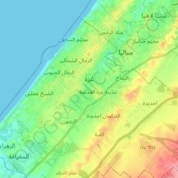
Name: Gaza topographic map, elevation, terrain.
Location: Gaza, Gaza Governorate, Gaza Strip, Palestinian Territory (31.46450 34.39615 31.54872 34.51814)
Average elevation: 36 m
Minimum elevation: 0 m
Maximum elevation: 118 m