
Thank you for supporting this site ❤️
Make a donation
Make a donation
Nammen topographic map
Click on the map to display elevation.
Thank you for supporting this site ❤️
Make a donation
Make a donation
About this map
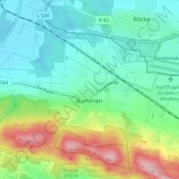
Name: Nammen topographic map, elevation, terrain.
Average elevation: 106 m
Minimum elevation: 46 m
Maximum elevation: 253 m
Thank you for supporting this site ❤️
Make a donation
Make a donation
Other topographic maps
Click on a map to view its topography, its elevation and its terrain.
Kleinenbremen
Deutschland > Nordrhein-Westfalen > Kreis Minden-Lübbecke > Porta Westfalica
Average elevation: 131 m
Porta Westfalica
Deutschland > Nordrhein-Westfalen > Kreis Minden-Lübbecke > Porta Westfalica
Average elevation: 80 m
Barksen
Deutschland > Nordrhein-Westfalen > Kreis Minden-Lübbecke > Porta Westfalica
Average elevation: 138 m
Vennebeck
Deutschland > Nordrhein-Westfalen > Kreis Minden-Lübbecke > Porta Westfalica
Average elevation: 58 m
Thank you for supporting this site ❤️
Make a donation
Make a donation
Vennebeckerbruch
Deutschland > Nordrhein-Westfalen > Kreis Minden-Lübbecke > Porta Westfalica
Average elevation: 86 m