
Thank you for supporting this site ❤️
Make a donation
Make a donation
Dayton topographic map
Click on the map to display elevation.
Thank you for supporting this site ❤️
Make a donation
Make a donation
About this map
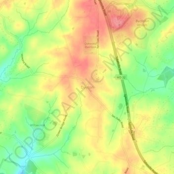
Name: Dayton topographic map, elevation, terrain.
Location: Dayton, Howard County, Maryland, 21036, United States (39.21927 -77.00664 39.25927 -76.96664)
Average elevation: 160 m
Minimum elevation: 112 m
Maximum elevation: 200 m
Thank you for supporting this site ❤️
Make a donation
Make a donation
Other topographic maps
Click on a map to view its topography, its elevation and its terrain.
Patapsco Valley State Park
United States > Maryland > Howard County > Ilchester
Average elevation: 131 m