
Thank you for supporting this site ❤️
Make a donation
Make a donation
Pond Creek topographic map
Click on the map to display elevation.
Thank you for supporting this site ❤️
Make a donation
Make a donation
About this map
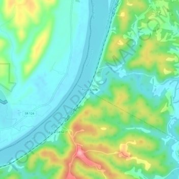
Name: Pond Creek topographic map, elevation, terrain.
Location: Pond Creek, Wood County, West Virginia, 26133, United States (39.07424 -81.76319 39.11424 -81.72319)
Average elevation: 210 m
Minimum elevation: 172 m
Maximum elevation: 301 m
Thank you for supporting this site ❤️
Make a donation
Make a donation
Other topographic maps
Click on a map to view its topography, its elevation and its terrain.