
Thank you for supporting this site ❤️
Make a donation
Make a donation
Center Grove topographic map
Click on the map to display elevation.
Thank you for supporting this site ❤️
Make a donation
Make a donation
About this map
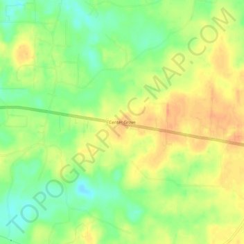
Name: Center Grove topographic map, elevation, terrain.
Location: Center Grove, Grant County, Arkansas, United States (34.29815 -92.31237 34.33815 -92.27237)
Average elevation: 89 m
Minimum elevation: 67 m
Maximum elevation: 107 m
Thank you for supporting this site ❤️
Make a donation
Make a donation
Other topographic maps
Click on a map to view its topography, its elevation and its terrain.