
Hille topographic map
Interactive map
Click on the map to display elevation.
About this map
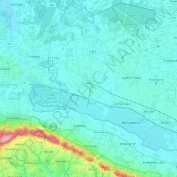
Name: Hille topographic map, elevation, terrain.
Average elevation: 70 m
Minimum elevation: 39 m
Maximum elevation: 309 m
Other topographic maps
Click on a map to view its topography, its elevation and its terrain.
Minden
Duitsland > Noordrijn-Westfalen > Kreis Minden-Lübbecke
Minden, Kreis Minden-Lübbecke, Noordrijn-Westfalen, Duitsland
Average elevation: 60 m
Porta Westfalica
Duitsland > Noordrijn-Westfalen > Kreis Minden-Lübbecke
Porta Westfalica, Kreis Minden-Lübbecke, Noordrijn-Westfalen, 32457, Duitsland
Average elevation: 85 m