
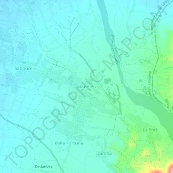
Matthieu topographic map
Interactive map
Click on the map to display elevation.
About this map
Name: Matthieu topographic map, elevation, terrain.
Average elevation: 54 m
Minimum elevation: 31 m
Maximum elevation: 173 m
Other topographic maps
Click on a map to view its topography, its elevation and its terrain.
Rivière Rouyonne
Haïti > Département de l'Ouest > Commune Léogâne
Rivière Rouyonne, Commune Léogâne, Arrondissement de Léogâne, Département de l'Ouest, Haïti
Average elevation: 185 m
Brache
Haïti > Département de l'Ouest > Commune Léogâne > Brache
Brache, Commune Léogâne, Arrondissement de Léogâne, Département de l'Ouest, CROIX-DES-PERES, Haïti
Average elevation: 31 m
Commune Léogâne
Haïti > Département de l'Ouest > Commune Léogâne
Commune Léogâne, Arrondissement de Léogâne, Département de l'Ouest, Haïti
Average elevation: 311 m